The Calaveras River watershed was selected by the California Department of Water Resources (DWR) as one of five watersheds to participate in the Watershed Resilience Program designed to pilot the planning of climate resilience at a watershed scale. The Watershed Resilience Program will advance the vision and framework described in the California Water Plan 2023 by providing financial and technical support to improve regional resilience. This important work will lay the foundation for future efforts within the Calaveras watershed and throughout the state of California.
The Calaveras River watershed includes portions of the counties of San Joaquin, Stanislaus, and Calaveras counties. The Calaveras River Watershed Resiliency Plan will help build regional resilience through multi-benefit projects, integrated resource management, and nature-based solutions with a focus on equity. This will be accomplished through a robust outreach and engagement process to foster collaboration, analyze and assess climate vulnerabilities and risks, develop adaptation and implementation strategies, and track performance against set metrics. The Watershed Resiliency Plan will incorporate feedback from a wide-ranging group of stakeholders known as the Watershed Network, ensuring a Plan that is inclusive of interests and perspectives from across our diverse watershed.
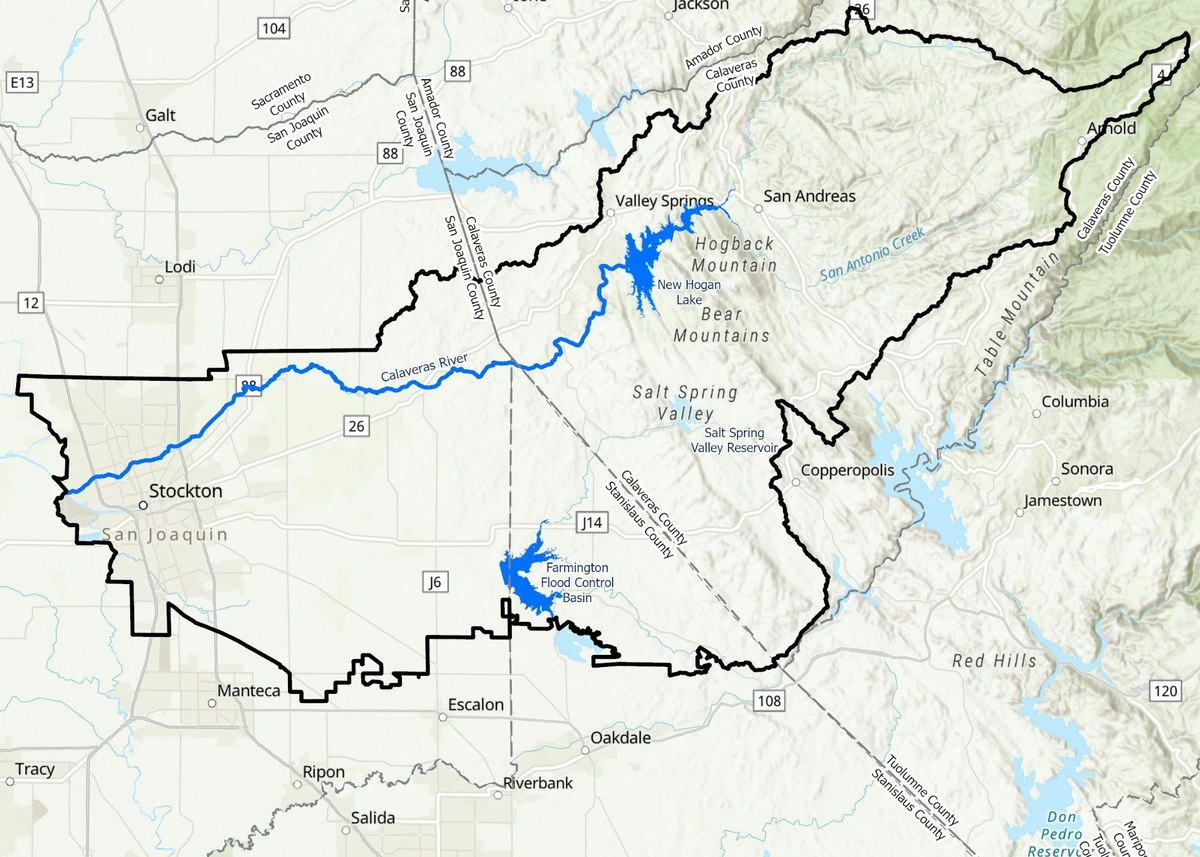
Determining the Watershed Boundary
Traditionally, watershed boundaries are determined by topography and elevation such that a watershed represents an area of land that drains to a particular outlet point. They are based on landscape characteristics (like topography and elevation), not jurisdictional boundaries (like cities, counties, or water districts). When determining the Calaveras River watershed boundary to be used as part of the Resiliency Study, the Project Team considered two main criteria: that the boundary capture the headwaters of the Calaveras River above New Hogan Reservoir and those areas downstream that may be impacted by changes to Calaveras River hydrology.
Using these two criteria, the watershed delineation for the purposes of the Calaveras River Watershed Resiliency Study was established in two steps:
- Determine the hydrologic boundary of the primary tributary to Calaveras River;
- Adjust the hydrologic boundary to accommodate for the boundaries of any irrigation districts that overlap the hydrologic watershed and whose surface water source is primarily associated with the Calaveras River watershed.
Effectively, this delineation represents a hydrologic boundary in the Upper Watershed (above New Hogan Dam) and both hydrologic and operational boundaries in the Lower Watershed. This modification for the Lower Watershed accounts for water districts that would be impacted by changes to the Calaveras River hydrology as a result of climate change, including Stockton East Water District and Central San Joaquin Water Conservation District.
Using this delineation for the Calaveras River Watershed Resiliency Plan also provides consistency with the California Department of Water Resources (DWR’s) Watershed Studies effort, which will be particularly beneficial for data sharing, tool development, and comparison of results. In an engineered environment like the Calaveras River, the study area for this Resiliency Plan is more comprehensive if the full climate change impact area is assessed, taking into account how water is delivered both through natural and engineered channels.
The Project Team (SEWD and CCWD) will work with participants in the Watershed Network to develop a collective vision for the watershed and goals for the Plan. The Watershed Network will play a critical role in providing feedback and helping guide the process. To participate in this process, please click below.
The Calaveras River Watershed Network is a structure that organizes stakeholders and interested parties for the Watershed Resilience Plan. We will look to the Watershed Network to support development of the plan by particiating in workshops, meetings, and online engagement opportunities.
A series of six online discussions are planned through the duration of the project. You can learn more about these discussions here.
Virtual Opportunities to Participate: Join us for a community discussion about the Calaveras River Watershed Plan. For updates on opportunties to particpate, please complete the form on Contact Us page. We will hold virtual workshops or you can also participate on your own schedule as the presentations become available.
Early 2025
-
Create Watershed Vision
Spring 2025
- Assess Climate Vulnerability and Watershed
Summer 2025
-
Early Summer 2025: Assess Vulnerability and Risks
-
Summer 2025: Develop Adaptation Strategies
Spring 2026
-
Develop Performance Tracking Approach
Fall 2026
-
Finalize Watershed Resilience Plan